
Tuesday, September 22, 2020
Fall Explorations at Mt. Tom State Reservation
Sunday, September 13, 2020
Seekonk Town Hall Trails in SE Massachusetts
 |
| Trail head behind town hall. |
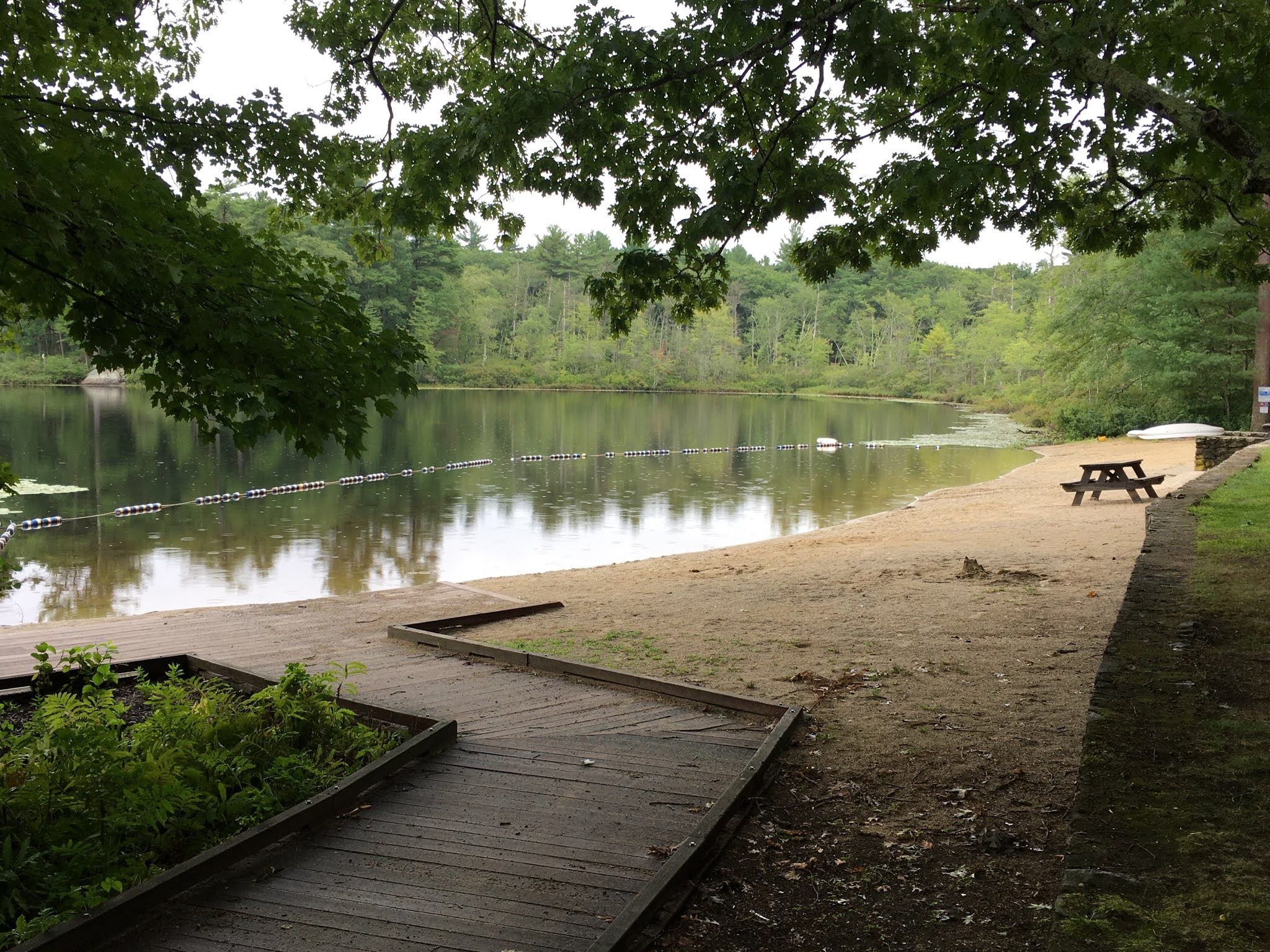
The town of Seekonk in southeastern Massachusetts - not far from Providence, RI - has a nice accessible trail starting right at the town hall. This trails project, partially funded through DCR's Recreation Trails Grant program, offers visitors an opportunity to hike through the woods to a wetland view.
The town hall can be found at 100 Peck Street. Once there you'll find a brand new accessible playground right at the town hall, along with a picnic area and new parking lot. When I visited in August these new features were still under construction but close to being finished.
 |
| Shady deck ends the accessible trail portion. |
A short partially paved access route will bring you to the start of the red trail just beyond the picnic tables. What I like about this short trail - just 1/6 of a mile - is how easy it is to slip into nature in an urban environment. The stone dust path soon reaches a trail junction. From here, the accessible yellow trail will take you through the woods to the YMCA. The red trail continues to a tiny observation deck before it changes to boardwalk that leads to a larger deck. Along this route you can observe various plants and potentially wildlife in a damp forest. Reaching the deck view completes the wheelchair accessible portion of the trail - a worthy and enjoyable journey.
Wednesday, September 9, 2020
Take a Tree Walk at Beaver Brook Reservation

I recommend parking in a 40 car lot on Waverly Oaks Road across from #520 to begin your excursion at Beaver Brook Reservation. You'll have to contend with a downgrade to get into the park (as shown in the first photo), but the paved path is 12 feet wide, which allows other people to pass by. The downgrade is 6-13% for 160 feet, followed by another at 10-18% for 60 feet - definitely significant, but doable with support if needed. A power wheelchair is unlikely to have an issue. You could also start out taking the roadside sidewalk and do a gradual descent into the park, then return the same way after exploring the park to avoid the steepest section. Just remember either way you will have to return uphill.
The park was well visited on a Thursday afternoon and likely is on any day of the week. No bathrooms here, so be forewarned.
Friday, September 4, 2020
Explore an Accessible Trail with Pond and Pavilion at Harold Parker State Forest
Berry Pond, a highlight of the state forest and located at 700 Middleton Road in North Andover, has several accessible features - parking, accessible bathrooms, an accessible boardwalk to a small beach, beach wheelchairs and a trail head for the accessible trail. This is a popular weekend swimming and picnic area open between Memorial Day and Labor Day. The road into this day use area closes after Labor Day, but you can still explore the area if you park nearby.
Tuesday, September 1, 2020
Chicopee Reservoir Path and Healthy Heart Trail
 |
| Approaching the beach |
Chicopee Memorial State Park is located east of Springfield just off exit 6 on the Mass Pike. The address is 570 Burnett Road, Chicopee, MA. The park is usually quite busy in the summer, but visitation tapers off by mid-August. When I was there two weeks ago, only a few people were sunning themselves on the beach and a few families and individuals were out on trails. Most people were not wearing masks, but this did not present an issue as the trails are very wide. Dogs are allowed on leash.
Monday, August 24, 2020
Reflect on Healing in Nature at Attleboro Springs


Thursday, August 20, 2020
Lake Park in Worcester Provides One-way Trail Loop

I visited Lake Park, part of Quinsigamond State Park, on a hot summer Friday afternoon. Located at 283 Lake Avenue in Worcester, this urban park is across the street from Buffone Skating Arena, with tennis courts visible from the road which you will pass on your right as you pull into the parking lot. There are several accessible parking spots here: 2 in front of the tennis courts, 4 across from the trailhead, and 4 more by the swim beach. I was inspired to visit Lake Park after hearing there was a one-way trail loop system implemented in an effort to reduce contact with other trail users and promote social distancing while still being active outdoors. You may also want to visit nearby Regatta Point at 10 N. Lake Ave. for views of Lake Quinsigamond. Both locations constitute Quinsigamond State Park.
Monday, August 17, 2020
Along the Old Mill Trail in the Berkshires

The wheelchair accessible portion of the Old Mill Trail is 3/4 of a mile along the 1.5 mile linear trail that starts at the intersection of Old Dalton Road and Route 8. Continuing on beyond the 3/4 mile accessibility point will soon get you into more roots and rocks as the trail crosses under Route 8 to its final turnaround point. Either way, bear in mind to double the distance for your total hiking mileage. The trail is flat to moderate terrain and hard-packed dirt and stone dust. A kiosk at the trail head will help with onsite orientation. You can also click here for a map.
Thursday, August 13, 2020
Jordan Pond - A Quieter Trail Outing Near Worcester
Thanks again to Laila Soleimani, from DCR's Universal Access Program, for finding a quiet spot in the Worcester Area we can recommend for local folks.

This accessible walking trail is paved, flat, about 7.5 ft wide and runs along Jordan Pond (please note: there is also a non-accessible wood path/dirt road which runs along the other side of the pond). From the parking lot down the paved trail and back is just shy of a mile at approximately 0.8 miles long. There are no restrooms here, but there are many fast food restaurants located about a half mile away where you can find bathrooms available. I barely heard the sound of cars or traffic in the area.
Wednesday, August 12, 2020
The Canalside Rail Trail - Spacious Outing Along a Power Canal

Rail trails are by nature wheelchair accessible, since they follow old railroad beds with flatter grades. This is one of DCR's shortest rail trails, and least known, making it a good candidate for anyone who'd like to venture out onto a rail trail these days. I hear many reports and concerns about overcrowded rail trails as people flock to major places to recreate this summer. I've been to Canalside several times and always see people, but well spread out. Several access points help to users maintain good distance.

For best accessibility to the Canalside Rail Trail, I recommend the quieter Connecticut River end of the trail in Deerfield. From River Road find McClelland Farm Road where you will quickly locate a paved parking lot with a level access route to the trail. For a good overview of the trail, click here for a map. This will help reference the various highlights mentioned next.
Subscribe to:
Comments (Atom)